Proposed Beverley to Narrogin Trail
About the proposed trail
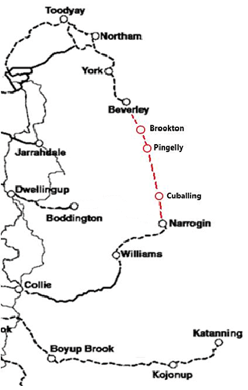
The Wheatbelt may get a new long-distance cycle and walk trail network between Beverley and Narrogin. Five local governments (Beverley, Brookton, Pingelly, Cuballing and Narrogin) are investigating the feasibility of a cycling and walking route between Beverley and Narrogin.
The proposal is for a cleared narrow trail that primarily follows the railway and/or Great Southern Highway between all the towns from Beverley to Narrogin and return route that primarily uses existing quiet, gravel backroads linking all the towns and other places of interest. This trail network will:
- Directly connect the towns of Beverley, Brookton, Pingelly, Popanyinning, Cuballing, and Narrogin
- Make each town a trails destination, with a loop trail commencing and finishing in the town, connecting local points of interest.
- Link these towns into existing trail networks at Beverley and Narrogin.
- Complete an 800km loop of proposed trails including the Munda Biddi and Bibbulmun Track. This makes it the longest loop trail in Australia and 6th longest in Australia overall.
- Connecting to planned rail trails from Narrogin to Williams
|
 |
The route along the rail is approximately 105km. This will be a dedicated track separate from vehicles. However, due to construction constraints, it is likely that this trail will take a significant time to be developed.
The route using existing gravel roads is significantly simpler to construct and therefore can be developed once funding allows. This route passes a number of historic sites, including old school sites, old townsites and through the Dryandra Woodland National Park. However, this route is on-road and therefore may not be suitable for all.
Beverley to Narrogin Transport Trail
The Beverley to Narrogin Transport Trail is an exciting regional initiative exploring the development of a long-distance cycling and walking trail network through the Wheatbelt, connecting the Shires of Beverley, Brookton, Pingelly, Cuballing and Narrogin.
The project has been shaped through strong collaboration between the five local governments and extensive community feedback, helping to inform route options, priorities, and opportunities along the corridor.
Two potential trail options have been investigated:
- A dedicated off-road trail largely following the railway reserve and/or Great Southern Highway, providing a purpose-built shared-use path between Beverley and Narrogin.
- A secondary return route using existing quiet gravel backroads, linking townsites, heritage locations, and key natural attractions including the Dryandra Woodland National Park.
Together, these routes highlight the potential for a unique regional experience that combines recreation, tourism, heritage, and connectivity across the Wheatbelt.
We are now at the stage where detailed planning and feasibility work has been completed. The project documentation is being made available, including:
These reports provide the foundation for future funding applications and delivery, making the project “shovel ready” for when funding opportunities become available. Delivery remains subject to external funding.
Related Documents & Plans
You can view the Proposed Transport Trail Interim Report and Plans via the links below: